
-
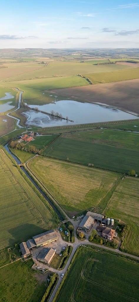
- Design: Consists of a single flood storage reservoir on the River Bain upstream of Horncastle, using about 200 acres of agricultural land.
- Partners: Developed by the Environment Agency alongside local councils, Anglian Water, and drainage boards.
- Purpose: Built to hold back excess river water during heavy rain and release it safely later. [1, 2]
- The Failure: During Storm Babet in October 2023, up to two months of rain fell in 24 hours, and a reservoir sluice gate failed to operate automatically. [1, 2]
-
Impact: Nearly 200 properties in Horncastle suffered from flooding. [1]
- Investigation: An Environment Agency report later stated that the rainfall exceeded the scheme’s design standard, though the agency also transitioned the gate to manual operation while reviewing its response. [1, 2]
1. Independent Peer Review & Section 19 Investigation (Lincolnshire County Council)
-
Peer Review Commissioned: Following local community frustration over the Environment Agency (EA) “marking its own homework” regarding the 2.5-hour delay in closing the flood storage reservoir sluice gate, Lincolnshire County Council (LCC) agreed to commission an independent external peer review to double-check the EA’s findings.
-
Town-Wide Section 19 Investigation: LCC deployed independent consultants (GeoSmart) to carry out a comprehensive Section 19 investigation looking at Horncastle’s flooding as a whole (including surface runoff and drainage), separate from the EA’s narrow focus on the flood storage reservoir.
2. Asset Control & Operational Changes (Environment Agency)
-
Control Switch System Fix: EA investigations revealed that the reservoir’s penstock/sluice gate had two conflicting override switches (one set to automatic, one set to manual). The EA committed to simplifying this setup to a single operational switch system to prevent future misconfiguration.
-
Improved Signal Communication: The EA updated system telemetry and alert signaling so shift handovers and receiving staff receive clearer descriptions of operational issues and asset errors in real time.
-
Swimming Bath Sluice Automation: To prevent delays caused by operatives needing to travel during severe regional events, the EA automated the swimming bath sluice control so physical attendance is no longer required to operate it.
3. Developer & Local Site Mitigation (Gleeson Homes / Developers)
-
Cut-Off Ditch Construction: In response to severe overland flooding into newly constructed housing areas (e.g., Winceby Gardens), Gleeson Homes installed a cut-off ditch with bunding on the eastern boundary to capture overland runoff from adjacent waterlogged fields and divert flows toward Thunker Drain before reaching properties.
Horncastle Flood Storage Reservoir
The Environment Agency carried out its Chief Engineer review after Storm Babet. An independent GeoSmart review followed in October 2024. Since then, the EA says it has been implementing the recommendations. The December 2025 update states that:
- the reservoir design was checked against current industry standards;
- minor improvements are being made;
- the ability to switch between automatic and manual operation has been simplified;
- the reservoir now operates automatically by default;
- manual operation requires a key held by trained and competent staff;
- software controlling the reservoir has been backed up;
- reservoir alarm messages have been revised to distinguish between “for information” and “for action” alarms;
- remaining recommendations from the Chief Engineer’s review were still being addressed.
So, yes, work has been undertaken since the 2024 meeting, but the published information describes much of it as operational/control-system improvements and minor physical improvements rather than a completely new flood-defence scheme.
What about High Street and the surrounding villages?
This is important because the reservoir doesn’t protect every source of flooding.
The EA previously explained that the Horncastle reservoir was designed to reduce flooding along the River Bain, but flooding can also come from other watercourses and drainage systems. During Storm Babet, around 197 properties were flooded according to the EA’s review reported at the April 2024 meeting.
Lincolnshire County Council completed its Section 19 investigation into the Horncastle flooding. The Council subsequently monitored the recommendations with the relevant organisations through quarterly meetings.
The Council also reported that it was working with affected landowners, farmers and around 40 communities to identify additional flood-mitigation measures.
There is still a question about future risk
The October 2024 scrutiny meeting specifically discussed properties being developed near the River Waring and Thunker Drain and requested that the Environment Agency consider flood-protection options. The EA had determined that a potential reservoir on the Waring was inappropriate, while a multi-agency group involving the EA, Lincolnshire County Council, Internal Drainage Boards and Anglian Water was working on flood prevention around Thunker Drain.
Thunker Drain is therefore one of the waterways worth looking at separately from the Bain/reservoir issue.
If you’re concerned about Baumber
Baumber and the surrounding villages need to be considered separately from the Horncastle reservoir because the reservoir’s catchment and the sources of surface-water, ordinary-watercourse and drainage flooding aren’t necessarily the same.
The most useful next step would be to examine the Section 19 recommendations village-by-village, particularly Horncastle, Baumber, High Street, Thornton, Tetford, Roughton, Mareham-on-the-Hill and the villages downstream of the Bain, and establish:
—————————————————————————————————————————
Subject: Horncastle flooding — actions identified at public meeting 25 April 2024
Dear Martin,
I have been reviewing the Environment Agency information provided at the Horncastle public meeting on 25 April 2024.
Under the heading “What happens next?”, the EA stated that it would:
- “Revisit and reassess viability of previous plans to create a reservoir on the River Waring.”
- “Investigate possible options to reduce risk along Thunker Drain.”
- “Investigate whether minor bank works might be needed in the town to fill in localised low spots.”
Please confirm, for each of these three actions:
(a) whether the work was carried out;
(b) when it was carried out and by whom;
(c) what conclusions were reached;
(d) what physical works, if any, have subsequently been undertaken; and
(e) where the relevant assessments, reports, surveys or option appraisals can be obtained.
In particular, if the River Waring reservoir proposal was subsequently rejected as financially unviable or inappropriate, please provide or identify the technical and financial assessment upon which that conclusion was based.
These commitments were made publicly more than two years ago. I therefore believe it is reasonable to establish precisely what action followed them, particularly in light of the continuing questions surrounding the Horncastle Flood Alleviation Scheme and the Hemingby flood storage reservoir following Storm Babet.
I would appreciate a substantive response to each of the three points rather than a general update on the scheme.
With thanks
Yours sincerely
Alan M Dransfield

———————————————————————————————————————-
Subject: Hemingby Flood Storage Reservoir – Request for Original Hydraulic Design Information
Dear Martin,
I write to request clarification of the original hydraulic design and operation of the Hemingby flood-storage reservoir.
Please provide the following information:
- The original hydraulic design drawings, including drawings showing the main reservoir, concrete/grilled storage structure and associated pipework, culverts, valves and control structures.
- The design invert levels of all inlets and outlets serving the reservoir and concrete storage structure, stated in metres AOD where available.
- The normal and design operating water levels, including the level at which water enters the concrete storage structure.
- A drawing or explanation identifying the complete gravity-flow route by which water is intended to pass from the River Bain/main reservoir into the concrete storage structure.
- Confirmation of whether any permanent, temporary or mobile pumping arrangement formed part of the original design for filling or operating that structure.
- The name/organisation of the designer responsible for the hydraulic design and, if available, the relevant hydraulic calculations or design report.
This information is particularly important because the published photographs and the visible site levels do not make it apparent how the concrete storage structure could be filled by gravity. Rather than relying upon photographic interpretation, the original design levels and drawings should establish the position conclusively.
I would therefore appreciate copies of the relevant drawings and records, rather than a general description of the scheme’s operation.
Yours sincerely,
Alan M. Dransfield
————————————————————————————————————————
- Existing Reservoir: The Horncastle Flood Alleviation Scheme features a flood storage reservoir, but it captures water exclusively from the River Bain, leaving the River Waring and Thunker Drain unregulated by that specific facility. [1, 2]
- Past Decisions: Previous proposals for a River Waring reservoir were shelved because cost-benefit analyses indicated too few properties (roughly 15) were directly at risk from the Waring alone to justify a multi-million-pound capital expense. [1]
- Recent Reassessments: Following severe local flooding during Storm Babet, the Environment Agency faced mounting community pressure and announced it would revisit the viability of a River Waring reservoir alongside localized bank reinforcements and channel maintenance. [1, 2]
- Monitoring: The Environment Agency Check for Flooding Service actively tracks water levels for the river via the Horncastle Banks Road gauging station.