


To start with i visited this place ANDY FREEDOM TALK RADIO With Alan Dransfield
at the car park at freiston shore i saw a path wide enough for prams and wheelchairs
toilets and disabled parking.

Sadly thats it these people can not access the bank on the walk as stated.

https://www.rspb.org.uk/days-out/reserves/freiston-shore

it is a day out but not for disabled and prams amd on turning left
we saw the breached banks which looks dangerous see below and the path is uneven
and not wide for the people rspb and the arts council want to attract
the grass is overgrown and the paths stop.
come on tell the truth.

We spoke to many users who agreed.



Investigation Needed Urgently.
Freiston Shore Flood Defence Breach and Responsibility for Flood Protection
Alan Dransfield on 24th september 2026. live on freedomtalkradio from freiston shore boston.
To: Environment Agency
Cc: RSPB; Lincolnshire County Council; Boston Borough Council; Freiston Parish Council
Subject: Urgent request for clarification of responsibility, inspection and action concerning the flood-defence breach at Freiston Shore
Dear Sir/Madam,
I am writing to raise a formal concern regarding the apparent lack of clarity over responsibility for the flood-defence bank at Freiston Shore and, more importantly, the potential consequences for the surrounding communities should the existing breach or weakness in the defence remain unaddressed.
I understand that both the Environment Agency and the RSPB have indicated that they do not accept responsibility for the particular breach in question, with correspondence from the local Environment Agency reportedly informing Alan Dransfield that the Environment Agency has nothing to do with the issue at Freiston Shore and that responsibility rests with the RSPB.
This position appears difficult to reconcile with the historical government and Environment Agency documentation relating to the Freiston Shore managed realignment scheme.
The Environment Agency’s own historical documentation records that the existing flood defence at Freiston Shore was strengthened as part of the scheme. Government documentation states that the Environment Agency found strengthening the existing landward defence to be the appropriate flood-defence solution. The project was specifically intended to provide improved protection to the surrounding low-lying fenland.
Government documentation has also described the Environment Agency as working with the RSPB and other organisations on the Freiston Shore project and identified the flood-defence system as protecting extensive areas of low-lying Lincolnshire, including villages and agricultural land.
There therefore appears to be a significant discrepancy between the historical documented role of the Environment Agency in relation to the flood-defence system and the current assertion that the Agency has no responsibility for the particular bank now under concern.
1. Request for clarification of legal responsibility
I formally request that the Environment Agency and RSPB provide a clear and definitive explanation of the current responsibility for this section of the defence.
In particular, I ask that the following information be provided:
- Who currently owns the section of bank in question?
- Who currently has responsibility for inspecting, maintaining and repairing it?
- If responsibility previously rested with the Environment Agency, when did that responsibility cease?
- What legal agreement, transfer document, asset-management record, map, maintenance schedule or other formal document establishes the current allocation of responsibility?
- Please identify the precise document relied upon by the Environment Agency in stating that it has no responsibility for the present breach.
- Please explain how the current position relates to the historical Environment Agency and Defra documentation concerning the Freiston Shore flood-defence scheme.
- Please confirm whether the section of bank in question is classified or recorded within any Environment Agency flood or coastal-defence asset register, and if not, explain why not.
I do not believe that simply stating that the RSPB owns or manages the nature reserve is sufficient to establish that the RSPB is legally responsible for maintaining a particular flood-defence structure. Ownership of land and statutory or contractual responsibility for flood-defence infrastructure are not necessarily the same thing.
2. Previous flooding demonstrates the seriousness of the risk
This matter should not be considered in isolation.
The surrounding area has experienced significant flooding and flood-defence failures in the past.
The December 2013 tidal surge resulted in breaches of coastal defences in the area, including at Wrangle. Local documentation records the serious consequences of that event, including substantial land inundation and erosion.
More recently, the June 2019 River Steeping flooding resulted in approximately 550 hectares of land being flooded and the evacuation of approximately 580 houses in the region.
These events demonstrate that flooding in the wider area is not a theoretical possibility.
The relevant question is therefore not simply whether flooding is occurring today, but whether a known weakness or breach in a coastal defence is being left in a condition that could expose surrounding communities to increased risk during a future high-water, surge, storm or exceptionally wet period.
3. Concern regarding high tides and coastal conditions
There is particular concern regarding periods of high and spring tides, especially where high astronomical tides coincide with strong winds, storm surge or wave action.
A coastal defence that has already suffered a breach or structural failure requires appropriate inspection and risk assessment before such conditions occur.
I therefore request confirmation of:
- when the affected bank was last physically inspected;
- the findings of that inspection;
- whether the breach has been surveyed;
- whether its dimensions and condition have been recorded;
- whether erosion is continuing;
- whether the breach is becoming larger or deeper;
- whether wave overtopping or tidal inundation has been assessed;
- what contingency arrangements exist should the defence deteriorate further; and
- whether any temporary or permanent remedial works are currently planned.
4. Increasing concern regarding autumn 2026 conditions
There is an additional reason why this issue requires prompt attention.
The Met Office has reported that the 2026 El Niño event has now exceeded previous records and has stated that El Niño can increase the likelihood of wetter and windier conditions affecting the UK during autumn and early winter.
I recognise that El Niño does not mean that flooding at Freiston Shore is inevitable, and I am not suggesting that it can be used to predict a particular flood event.
However, it is entirely reasonable for the authorities responsible for flood risk management to consider the potential interaction between:
- an existing or reported breach;
- high and spring tides;
- storm surge;
- strong winds and wave action;
- previous local flood events;
- the low-lying nature of the surrounding land; and
- the possibility of wetter and windier autumn and early-winter conditions.
The Met Office itself states that increased likelihood of wetter and windier conditions can bring an increased risk of associated impacts such as flooding, although specific locations cannot be predicted at that timescale.
5. Risk to surrounding communities
My concern is therefore not limited to the RSPB reserve or to the ownership of the land immediately surrounding the breach.
The historical purpose of the flood-defence system was to provide protection to the wider low-lying area. Government documentation specifically identifies the surrounding fenland, villages and agricultural land as areas protected by the flood-defence improvements.
If a defence forming part of that wider system is breached, weakened or no longer maintained, then the potential consequences need to be assessed in terms of the whole flood-risk area, rather than simply the ownership of the reserve.
I am particularly concerned that the consequences of a failure could extend beyond the immediate site and affect surrounding villages, roads, agricultural land, homes and essential infrastructure.
6. Request for urgent risk assessment
In view of the above, I request that the Environment Agency, in conjunction with the RSPB and relevant local authorities, urgently:
- inspect the affected section of bank;
- establish and formally document who has responsibility for it;
- assess the structural condition of the defence;
- assess the consequences of a further breach or enlargement of the existing breach;
- assess the potential impact of high tides, storm surge and strong winds;
- confirm what emergency measures are available should the defence deteriorate;
- establish whether surrounding communities would be placed at increased flood risk;
- confirm whether the present condition of the bank is considered acceptable under the relevant flood-risk management arrangements; and
- provide residents and local representatives with a clear explanation of what action, if any, is being taken.
7. Request for documentary evidence
I would also ask that copies of the relevant records be provided, including:
- current asset ownership records;
- maintenance responsibility records;
- relevant maps;
- inspection reports;
- condition assessments;
- photographs or surveys of the breach;
- previous maintenance and repair records;
- any agreement transferring responsibility between the Environment Agency and RSPB;
- relevant flood-risk assessments;
- emergency plans relating to the defence; and
- any correspondence or internal decision recording the basis upon which the Environment Agency considers that it has no responsibility for this section of the defence.
Conclusion
The central issue is not an argument between two organisations over who owns a piece of land.
The central issue is who is responsible for ensuring that a flood-defence structure protecting the wider area is properly inspected, maintained and, where necessary, repaired.
The historical documentation demonstrates that flood defence was a fundamental purpose of the Freiston Shore scheme. There have subsequently been serious flooding events in the wider area, including both tidal and fluvial flooding.
Given the reported breach, the history of flooding in the surrounding area and the current autumn and winter weather outlook, I believe it is reasonable to request that this matter is treated as an urgent flood-risk issue rather than simply an ownership dispute.
I would therefore appreciate a substantive written response addressing each of the questions above, together with the documentary evidence establishing who currently has responsibility for the defence and what measures are being taken to protect the surrounding communities.
Please also treat this correspondence as a formal request for the relevant information and, where applicable, as a formal complaint regarding the apparent uncertainty over responsibility for the flood-defence infrastructure.
I look forward to receiving a full response.
Yours faithfully,
freedomtalkradio2013@gmail.com


Alan Dransfield a boston man and resident currently has written to Mr Tice and the reform party and sadly not 1 email has been recieved from several sent.
Like many mps the rules state they dont have to reply but flooding worries will loose their votes as peoples lives are in danger.
Reform UK MP for Boston and Skegness Richard Tice has criticized the Environment Agency regarding the operation and maintenance of local flood defences, including the £100 million Boston tidal flood barrier. [1, 2]
- Tice’s Criticisms: Following flooding incidents in the area (such as when the South Forty Foot Drain overtopped), Tice stated that local flood bosses and the Environment Agency failed residents. According to, Tice claimed that the agency cares more about “badgers and water voles” than flood victims and criticized a lack of proper river dredging. [1, 2]
- Broader Context: Tice has argued that his highly flood-vulnerable constituency requires faster investment in repairing and upgrading old flood defences rather than prioritizing long-term net-zero climate policies, which he contends diverts necessary funds away from immediate local protection. [1, 2, 3]
https://consult.environment-agency.gov.uk/engagement/boston-barrier/
IN 2026 THESE DOORS ARE STILL NOT INSTALLED HIGHTIDE ELNINO AND THE WINTER STORMS ARE COMING.
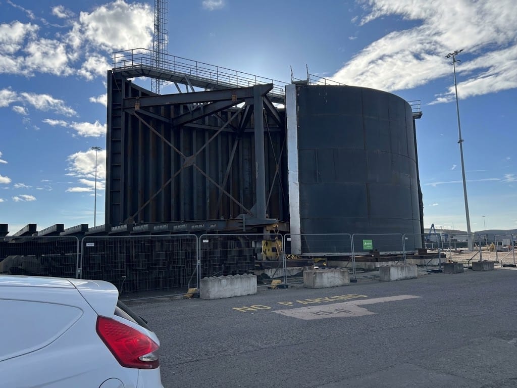
What Is Shown in the Image
-
Structure: These are the Vertical Sector Gates (VSG) fabricated by Hollandia Infra for the Port of Boston Wet Dock Entrance.
-
Design: Unlike the main river barrier (which is a rising sector gate that rests on the riverbed), these two curved segment doors swing horizontally from recesses in the quay walls—similar in principle to the Maeslantkering storm surge barrier in the Netherlands.
Specifications & Key Measurements
-
Quantity & Weight: Two matching sector doors, each weighing approximately 100 tonnes (200 tonnes total).
-
Height: Approximately 10 metres high.
-
Span / Span Width: Designed to swing together to close off an 18-metre wide passage at the wet dock entrance.
Why They Are Staged Here (Not Yet Installed)
-
Phased Construction Order: The primary phase of the £100M+ Boston Barrier Scheme focused on the main river barrier across The Haven (the 25m/26m wide, 300+ tonne rising sector gate, operational since late 2020). The wet dock entrance modification is part of the final phase of the project.
-
Complex Engineering Preparation: Before these doors can be set into place, the existing 16m lock structure must be widened to 18m, which involves extensive sheet piling, concrete recess construction, hydraulic mechanism installation, and quay wall reinforcement.
-
On-Site Assembly & Staging: Delivered via transport barge/heavy transport from Hollandia’s fabrication yard in the Netherlands, they are temporarily stored in the secure construction compound adjacent to the Port of Boston estate for off-river assembly, fitting checks, and surface coating inspections prior to crane placement.
Security Measures
The site is protected by perimeter fencing, concrete ballast blocks, and security monitoring because:
-
It is an active heavy construction zone containing heavy machinery, hydraulic systems, and critical infrastructure.
-
These gate leaves are high-value, critical national flood defense infrastructure for the Environment Agency.
For a clear view of the structures without sun flare, the diagram below illustrates how these two vertical sector gate leaves operate:
               [ Port Quay Wall ]
             /                    \
     ( Recess )                  ( Recess )
        |                            |
        |----->  /          \  <-----|   <- 100t Curved Gate Leaves
        |       /            \       |      (10m High)
        +----------------------------+
            <--- 18m Entrance --->
When fully deployed, the two 100-tonne doors pivot outward from their quay recesses to meet in the center, sealing the 18-metre wet dock entrance against severe tidal surges.
========================================================================

Subject: Freiston Shore / Butterwick Marsh Outer Sea Bank – Environment Agency states bank is outside its remit
Dear Mr Tice,
I am writing to bring to your attention a concerning development regarding the Outer Sea Bank at Freiston Shore/Butterwick Marsh, Lincolnshire, which I have been investigating because of the open breaches in the bank and the potential implications for coastal flood protection.
The Environment Agency has now informed me that the section of sea bank I have raised concerns about is not owned, operated, maintained or managed by the Environment Agency, and that it undertakes no routine maintenance, inspections or repairs to that section.
I have also been told that the sea bank and associated tidal creeks fall outside the Environment Agency’s remit, with the RSPB identified as managing matters such as the site, access, fencing, warning signs and visitor safety.
This latest position causes me considerable concern.
During my inspections of the Freiston Shore/Butterwick Marsh coastline I have identified several substantial open breaches in the Outer Sea Bank. These are not minor surface defects. In places tidal creeks pass through the bank, creating what appear to be complete openings through what was historically a substantial coastal embankment.
I have repeatedly asked the Environment Agency to explain:
- Whether this Outer Sea Bank remains part of the area’s coastal flood-defence system.
- If it is no longer regarded as a flood defence, when and by whom that decision was made.
- What structure has replaced it as the principal line of coastal flood protection.
- Who owns and is responsible for inspecting and maintaining the breached sections.
- Whether the breaches are intentional components of managed realignment, historic breaches that are simply being left open, or defects requiring intervention.
- What flood-risk assessment demonstrates that these breaches do not increase the risk to communities and agricultural land inland of the coast.
There is also an apparent inconsistency which I believe requires clarification.
I have personally observed contractors carrying out substantial works to an embankment in the same general Freiston Shore area, including works which appeared to involve the landward slope/toe of the bank. Yet the Environment Agency now states that the section about which I have complained is outside its remit and that it neither maintains nor repairs it.
It is therefore important that the Environment Agency identifies precisely which embankment or flood-defence asset it is working on, who owns it, what its flood-defence function is, and how that structure relates to the breached Outer Sea Bank.
I am not satisfied that responsibility for a coastal embankment containing several major tidal breaches can simply remain unclear between the Environment Agency, landowners and the RSPB.
Given the potential consequences of coastal flooding around Boston and the Wash, I would be grateful if you would raise this matter with the Environment Agency at a senior level and ask for a clear statement identifying:
- the legally recognised coastal flood-defence line at Freiston Shore and Butterwick Marsh;
- the ownership and responsible authority for each relevant embankment;
- the Environment Agency’s precise statutory responsibilities in the area;
- the status and purpose of the existing breaches; and
- the assessment demonstrating that the present arrangement provides adequate protection to people, property and agricultural land inland.
I believe this matter deserves clarification before a major tidal event exposes any uncertainty in the present arrangements.
I would be grateful for your assistance and for any response received from the Environment Agency to be provided to me in full.
Kind regards,
Alan M. Dransfield

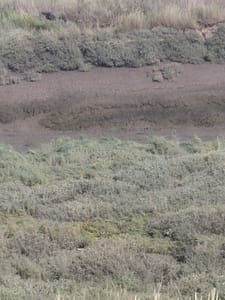
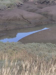
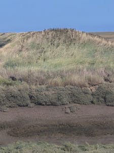
The current worries and breaches.
The large holes from the wash big enough for a boat to sail through will surely allow the sea in when at high tide elnino or a storm the only thing stopping this flooding the rspb area which was man made is a metal cat flap which is manually operated to help the birds live in happiness.
If the cat flap gets breached the towns will surely be flooded ?
Dear Mr Pearson,
Freiston Shore — Site Observations and Requests for Clarification Following Visit on 24 September 2026
Further to your recent correspondence concerning Freiston Shore, I visited the site again on 24 September 2026 and wish to formally record a number of observations and concerns arising from what I saw.
Given the extent of the works now taking place and the apparent changes to the movement of tidal water, I believe it is important that the RSPB provides clear information about what is being undertaken, why it is being undertaken, and which organisation has responsibility for the various structures involved.
1. New embankment and tidal-water arrangements
The RSPB reserve appears to have been extended towards North Sea Camp.
During my visit, I observed contractors constructing a substantial new embankment running between the landward sea bank and the outer sea bank. From its position and construction, it appears to form a dividing or retaining embankment associated with controlling or containing water within the extended reserve.
I also observed what appears to be a deliberate opening or breach in the seaward bank through which tidal water can enter the reserve.
I would therefore ask the RSPB to confirm:
- the purpose of this opening;
- whether it has been deliberately created as part of the current works;
- how tidal water is intended to enter the reserve;
- how water is intended to circulate through the site;
- how and where water is intended to leave the reserve; and
- what arrangements are in place to prevent uncontrolled erosion or enlargement of the opening.
Given the concerns already raised regarding breaches of the outer sea bank, I believe it is particularly important that the interaction between these new works and the existing flood-defence system is clearly explained.
2. Footpath along the breached outer sea bank
Approximately the first 500 metres of the route along the breached outer sea bank has now been cut back to provide a footpath.
I welcome the improvement and recognise the benefit of providing public access.
However, the usable path appears in places to be only approximately 500 mm wide.
This is extremely narrow for a public route and makes it difficult for people to pass one another safely. It also raises obvious questions concerning accessibility for people using wheelchairs, mobility aids or pushchairs.
Given the apparent width available along the crest of the bank, please explain why the maintained route cannot extend across a substantially greater proportion of the bank.
Please also confirm whether the route has been assessed against the relevant public-access and accessibility requirements.
3. Remaining barbed wire — public and wildlife safety
Although some of the barbed wire previously obstructing the route has been cut back, sections appear to have been left alongside the fence posts.
In my view, this remains an unnecessary and avoidable hazard to members of the public, particularly children, and potentially to wildlife.
Simply cutting the wire back and leaving the remaining sections beside the route does not appear to provide an adequate long-term solution.
I therefore request that the remaining redundant barbed wire is completely removed and safely disposed of, rather than left alongside the public route.
Please confirm whether this will be undertaken.
4. Public information and signage
I was also surprised that I did not see what I would have expected to be appropriate signage in light of the changes taking place.
In particular:
A. Coastal Path signage
The existing Coastal Path sign appears to require realignment or updating to reflect the altered route and current conditions.
Please confirm whether the signage is to be relocated and updated.
B. Warning concerning contact with tidal water, shellfish and samphire
I would also have expected to see a clear warning to members of the public concerning the potential health risks associated with contact with tidal water and the consumption or handling of shellfish and samphire in the area, particularly where there may be concerns regarding E. coli or other waterborne contamination.
If the RSPB considers that such a warning is unnecessary, please explain the basis for that decision and identify any relevant water-quality assessment or advice upon which it relies.
5. Wildlife welfare
During my visit I also observed two swans within the original reserve which appeared to be repeatedly pacing along the fencing and showing signs of distress.
I appreciate that an observation of this nature does not, by itself, establish the cause of the behaviour. Nevertheless, given the extent of the works and changes to the site, I believe it warrants attention.
Please confirm whether the welfare and movement of birds and other wildlife within the original reserve are being monitored while these works are taking place, and whether measures are being taken to ensure that fencing and construction works do not unnecessarily restrict wildlife movement.
6. Responsibility for the various structures
The scale of the works and the apparent changes to tidal-water arrangements make it particularly important to establish who is responsible for the various structures at Freiston Shore.
I therefore request clear confirmation of which organisation designed, authorised, owns, operates and maintains each of the following:
- the breached outer sea bank;
- the new dividing/retaining embankments;
- the openings through which tidal water enters the reserve;
- any structures controlling the movement, level or retention of water within the reserve; and
- any associated flood-defence or coastal-defence structures.
Please also identify any relevant agreements or arrangements between the RSPB, Environment Agency or other organisations concerning these structures.
7. Relationship with the wider flood-defence system
I would particularly appreciate clarification of how the current works relate to the wider flood-defence arrangements for Freiston Shore and the surrounding communities.
This is important because the area has a history of significant flooding and because concerns have already been raised regarding breaches of the outer sea bank.
I do not believe that responsibility for these structures should remain unclear where there is potential for failure, erosion or uncontrolled movement of tidal water to have consequences beyond the RSPB reserve itself.
I would therefore appreciate a clear explanation of how the current works have been assessed in relation to the wider flood-risk management arrangements.
Conclusion
These observations are based solely upon what was visible during my site visit on 24 September 2026, and I fully appreciate that some of the matters described above require confirmation from the RSPB.
However, the extent of the works, the apparent introduction or enlargement of tidal-water openings, the condition of the outer sea bank, the changes to public access and the lack of clarity over responsibility make it important that these questions are answered fully.
I would therefore be grateful for a substantive response addressing each of the points above, rather than a general response concerning the reserve as a whole.
In particular, I would ask that the RSPB provides:
- an explanation of the purpose and design of the new embankments;
- an explanation of the tidal-water openings;
- clarification of responsibility for the outer sea bank and associated structures;
- confirmation of the arrangements for public access and accessibility;
- confirmation that the remaining barbed wire will be removed;
- clarification regarding the Coastal Path signage;
- confirmation of any public-health/water-quality warnings considered necessary;
- confirmation of wildlife monitoring during the works; and
- details of any relevant consultation or approvals associated with these works.
I would appreciate a response at your earliest opportunity, particularly given the continuing concerns regarding the condition of the outer sea bank and the potential implications for the wider area.
Yours sincerely,
Alan M. Dransfield
The actual breeches taken years ago.


This shows ea at least used to have the responsibility.
The reason the banks was breached.
- A Bank Too Far: In 1983, the HM Prison Service (working from the nearby HMP North Sea Camp) built an outer embankment to reclaim 66 hectares of saltmarsh from The Wash for arable farming. However, this outer bank protruded too far into the sea and faced severe, unsustainable wave erosion during the 1990s. [1, 2, 3]
- Habitat Creation: The tidal exchange through these breaches sustains a thriving intertidal ecosystem. Coupled with an artificially created 15-hectare brackish lagoon behind the inner embankments, it serves as a critical nursery for fish and a massive roosting site for tens of thousands of wintering wading birds, such as avocets and red knots. [1, 2]
Remember this boston.
https://www.facebook.com/watch/?v=495764126952586
https://www.newsflare.com/video/315712/quayside-flooded-in-boston-lincolnshire-uk
EMAIL YOUR CONCERNS.
boston.barrier@environment-agency.gov.uk
https://www.facebook.com/BostonBarrier/?locale=en_GB
Flood Issues EA
Dame Angela Eagle DBE was appointed Secretary of State for Environment, Food and Rural Affairs on 20 July 2026
enquiries@environment-agency.gov.uk
LNplanning@environment-agency.gov.uk
EMDenquiries@environment-agency.gov.uk
communications_midlands@environment-agency.gov.uk
GOVERMENT DEPTS.
lnenquiries@environment-agency.gov.uk
RSPB.
lincolnshirewashreserves@rspb.org.uk
Boston Councillors and lincolnshire mps.
Richard Tice MP Boston Skegness.
cllra.arundell@lincolnshire.gov.uk
cllrk.bamford@lincolnshire.gov.uk
Boston Councillors
https://freiston.parish.lincolnshire.gov.uk/
https://www.facebook.com/groups/1021992358011969/?locale=en_GB
Councillor Alison Austin
c/o Municipal Buildings
West Street
Boston
Lincolnshire
PE21 8QR
07731 690034
Councillor Richard Austin BEM
c/o Municipal Buildings
West Street
Boston
Lincolnshire
PE21 8QR
01205 314511
Councillor John Baxter
c/o Municipal Buildings
West Street
Boston
Lincolnshire
PE21 8QR
07815 545249
Councillor Peter Bedford
(Address not supplied)
01205 761957
07484 881633
Councillor Dale Broughton
c/o Municipal Buildings
West Street
Boston
Lincolnshire
PE21 8QR
01205 314228
Councillor David Brown
c/o Municipal Buildings
West Street
Boston
Lincolnshire
PE21 8QR
Councillor Callum Butler
c/o Municipal Buildings
West Street
Boston
Lincolnshire
PE21 8QR
07944 789 515
Councillor James Cantwell
c/o Municipal Buldings
West Street
Boston
Lincolnshire
PE21 8QR
07766 227639
Councillor Emma Cresswell
c/o Municipal Buildings
West Street
Boston
Lincolnshire
PE21 8QR
01205 314511
Councillor Anton Dani
c/o Municipal Buildings
West Street
Boston
Lincolnshire
PE21 8QR
07979 189293
Councillor Anne Dorrian
c/o Municipal Buildings
West Street
Boston
Lincolnshire
PE21 8QR
01205314511
07888 758608
Councillor Neil Drayton
c/o Municipal Buildings
West Street
Boston
Lincolnshire
PE21 8QR
01205 314511
Councillor Stuart Evans
c/o Municipal Buildings
West Street
Boston
Lincolnshire
PE21 8QR
07881 676303
Councillor Sandeep Ghosh
c/o Municipal Buildings
West Street
Boston
Lincolnshire
PE21 8QR
07368 473974
Councillor Mike Gilbert
c/o Municipal Buildings
West Street
Boston
Lincolnshire
PE21 8QR
01205 314228
07981 699273
Councillor Paul Gleeson
c/o Municipal Buildings
West Street
Boston
Lincolnshire
PE21 8QR
Councillor Andy Izard
c/o Municipal Buildings
West Street
Boston
Lincolnshire
PE21 8QR
07552 923161
Councillor Patricia Marson
Municipal Buildings
West Street
Boston
Lincolnshire
PE21 8QR
07399 568522
Councillor David Middleton
c/o Municipal Buildings
West Street
Boston
Lincolnshire
PE21 8QR
07716 166677
Councillor Chris Mountain
c/o Municipal Buildings
West Street
Boston
Lincolnshire
PE21 8QR
07514 809092
Councillor Jonathan Noble
c/o Municipal Buildings
West Street
Boston
Lincolnshire
PE21 8QR
01205 750657
07964 115227
Councillor Barrie Pierpoint
c/o Municipal Buildings
West Street
Boston
Lincolnshire
PE21 8QR
07720 406806
barrie.pierpoint@boston.gov.uk
Councillor Ralph Pryke
Marsh Bank Cottage
Frampton Roads
Frampton
Boston
PE20 1AY
01205 722693
Councillor Claire Rylott
c/o Municipal Buildings
West Street
Boston
Lincolnshire
PE21 8QR
07534 433218
Councillor Lina Savickiene
c/o Municipal Buildings
West Street
Boston
Lincolnshire
PE21 8QR
07453 053330
Councillor David Scoot
c/o Muncipal Buildings
West Street
Boston
Lincolnshire
PE21 8QR
01205 354250
07930 910831
Councillor Sarah Sharpe
c/o Municipal Buildings
West Street
Boston
Lincolnshire
PE21 8QR
07538 577355
Councillor Helen Staples
c/o Municipal Buildings
West Street
Boston
Lincolnshire
PE21 8QR
01205 366417
07944 754844
Councillor Suzanne Welberry
c/o Municipal Buildings
West Street
Boston
Lincolnshire
PE21 8QR
07799 888763
suzanne.welberry@boston.gov.uk
Councillor Stephen Woodliffe
44 Chester Way
Boston
PE21 7PR
07876 086570
stephen.woodliffe@boston.gov.uk
lincs county council
https://lincolnshire.moderngov.co.uk/mgMemberIndex.aspx?bcr=1
MEDIA.
c4investigations@protonmail.com
Andy.Hubbert@iconicmediagroup.co.uk
andy.hubbert@nationalworld.com
richard.silverwood@iconicmediagroup.co.uk
david.seymour@iconicmediagroup.co.uk
admin@southlincolnshireartists.org
investigations@theguardian.com
info@environmentalinvestigations.co.uk
ALAN DRANSFIELDS CONCERNS.